

is climate change to blame for New Zealand's summer of extreme weather?
- Written by: James Renwick, Professor, Physical Geography (climate science), Te Herenga Waka — Victoria University of Wellington
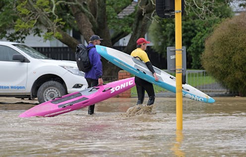
The final months of New Zealand’s summer carried a massive sting, bringing “unprecedented” rainfalls several times over, from widespread flooding in Auckland at the end of January to ex-tropical Cyclone Gabrielle dumping record rains and causing devastating floods across the east coast of the North Island.
After all that, New Zealand experienced spells of thunderstorms, bringing repeat floods to parts of Auckland and then Gisborne.
The obvious question is what role climate change plays in these record-breaking rainfalls.
Some answers come from the international World Weather Attribution[1] team, which today released a rapid assessment[2] which shows very heavy rain, like that associated with Cyclone Gabrielle, has become about four times more common in the region and extreme downpours now drop 30% more rain.
The team analysed weather data from several stations, which show the observed increase in heavy rain. It then used computer models to compare the climate as it is today, after about 1.2℃ of global warming since the late 1800s, with the climate of the past.
The small size of the analysed region meant the team could not quantify the extent to which human-caused warming is responsible for the observed increase in heavy rain in this part of New Zealand, but concluded it was the likely cause.
Read more: Climate change is making flooding worse: 3 reasons the world is seeing more record-breaking deluges and flash floods[3]
More energy in the atmosphere and ocean
Many factors add to the strength of a storm and the intensity of rainfall, especially for short bursts. A crucial factor is always the amount of energy available.
Climate change is increasing that amount of energy in two main ways. First, everything is getting warmer. Rising sea surface temperatures provide extra fuel for the development of tropical cyclones[4] because they grow by heating from below.
Warmer seas mean potentially faster development of tropical cyclones, and stronger, more vigorous storms overall. Sea temperatures must be at least 26.5℃ to support the build-up of a tropical cyclone. So, as the oceans warm, these storms can reach farther from the equator.
Second, warmer air can hold more water vapour. Every degree of warming increases the maximum amount of water vapour by around 7%. That extra water vapour tends to fall out as extra rain, but it also provides extra energy to a storm.
Read more: The Auckland floods are a sign of things to come – the city needs stormwater systems fit for climate change[5]
Driving waves further inland
The energy it takes to evaporate the water from the ocean surface and turn it into vapour is released again when the vapour condenses back into liquid water. A moister airmass heats the atmosphere more when clouds and rain form, making the air more buoyant and able to rise up more. This creates deeper, more vigorous clouds with stronger updrafts, and again more rain.
Stronger updrafts in a storm mean more air will have to be drawn into the storm near the Earth’s surface, ensuring more “convergence” of air and moisture (water vapour). That’s why, even though a degree of warming translates to 7% more water vapour in the air, we can get 20% increases, or larger, in extreme rainfalls.
All of this extra energy can contribute to making the storm stronger overall, with stronger winds and lower air pressures in its centre. This seems to have happened with Cyclone Gabrielle. Record low pressures were recorded at a few North Island locations as the storm passed.
The low pressures act like a vacuum cleaner, sucking the sea surface up above normal sea level. The strong winds can then drive waves much further inland. Add in a bit of sea-level rise, and coastal inundation can get a lot worse a lot quicker.
As the climate continues to change, storm intensity is likely to increase on average, as sea levels continue to rise. Those effects together are bound to lead to more dramatic coastal erosion and inundation.
Thunderstorms riding warming seas
These processes work for thunderstorms as well. A thunder cloud often starts as a buoyant mass of air over a warm surface. As the air rises (or convects), it cools and forces water vapour to condense back to liquid water, releasing heat and increasing the buoyancy and speed of the rising air.
Again, that allows more moist air to be drawn into the cloud, and that convergence of moist air can increase rainfall amounts well above the 7% per degree of warming, for short bursts of very intense convection. The more intense the convection, the stronger the convergence of moisture and the heavier the resulting rainfall.
Tropical cyclones have rings of thunderstorms around their eye during the time when they are truly tropical storms. As they transition out of the tropics into our neighbourhood, they change their structure but retain a lot of the moisture and buoyancy of the air. An ex-tropical cyclone like Gabrielle, moving over very warm water, can pack a devastating punch.
Read more: What Australia learned from recent devastating floods – and how New Zealand can apply those lessons now[7]
Why has New Zealand had so much of this very heavy rain during the weeks from late January? Partly it’s the very warm ocean waters around Aotearoa (up to marine heatwave conditions) and farther north into the Coral Sea. That itself is partly related to the ongoing La Niña event in the tropical Pacific, which tends to pile up warm water (and tropical cyclones) in the west.
But it is also related to ongoing global warming. As sea temperatures increase, it becomes easier to reach heatwave conditions. Warmer seas load the atmosphere with water vapour.
Partly, too, the air over the North Island has been unusually “unstable” lately, very warm near ground level but cooler than normal higher up. That makes the buoyance in thunderstorms work even better and more strongly, encouraging very heavy rainfall.
These conditions seem to have eased now, but severe thunderstorms continue to develop. As we move from summer into autumn, as the warmest seas move eastwards away from us and as La Niña fades in the tropics, the chances of a repeat event are diminishing. For now at least.
But if we continue to warm the climate with more greenhouse gas emissions, we will continue to load the dice towards more very heavy rain over Aotearoa. Let us hope those regions and communities so badly affected by recent events have a chance to dry out, rebuild and recover before the next extreme weather.
References
- ^ World Weather Attribution (www.worldweatherattribution.org)
- ^ rapid assessment (spiral.imperial.ac.uk)
- ^ Climate change is making flooding worse: 3 reasons the world is seeing more record-breaking deluges and flash floods (theconversation.com)
- ^ extra fuel for the development of tropical cyclones (sciencebrief.org)
- ^ The Auckland floods are a sign of things to come – the city needs stormwater systems fit for climate change (theconversation.com)
- ^ CC BY-ND (creativecommons.org)
- ^ What Australia learned from recent devastating floods – and how New Zealand can apply those lessons now (theconversation.com)