


why the Auckland storm caused so many landslides – and what can be done about it
- Written by: Martin Brook, Associate Professor of Applied Geology, University of Auckland
The January 27 storm that hit Auckland broke all previous rainfall records[1] and has caused widespread damage[2], mostly from flooding and landslides. But while climate change helps explain the intensity of the rainfall, the way land has been used and built on in the city is a major factor in what happened.
Such rainfall events generate significant landslides, probably in the thousands. What geologists refer to as “multiple-occurrence regional landslide events” (MORLEs[3]) are sometimes also triggered by earthquakes (such as happened in Kaikoura in 2016[4]).
But predicting where and when land might slide is not easy. Influencing factors include local geology, the properties of the slope material (soil and/or rock), slope geometry and angle, surface vegetation cover, drainage, and any buildings which can add weight and “load” to a slope.
Combinations of these factors were involved in Auckland, and understanding what happened and why will be important for ensuring the city is protected from similar events in future.
Weak saturated soil
Auckland has weak, clay-rich soils formed by the weathering of underlying (often) weak rocks. It also has a lot of steep slopes. Even in their natural state, these slopes can be prone to sliding if the soils become saturated enough.
A further issue is the seasonal drying and wetting of soils. Auckland’s clay-rich soils show high “shrink and swell” properties, meaning there is a natural annual cycle of wetting (swelling) and drying (shrinking).
This can cause a progressive weakening of the soils over years and decades, called “strain-softening” (a bit like taking a steel fork and bending it back and forth). The soil is then more prone to failure when a large rainfall event occurs.
Read more: The Auckland floods are a sign of things to come – the city needs stormwater systems fit for climate change[5]
In theory, then, more extreme climate effects could lead to an increased rate of soil deterioration, causing the properties of the soil to change more rapidly.
Rainfall “thresholds” are also important to consider. These are the rainfall totals – measured across either 24, 48 or 72 hour intervals – that can initiate landslides on a given slope. But using rainfall forecasts to predict landslides oversimplifies the issue because the prevailing (“antecedent”) soil moisture conditions are also important.
Soils are made of solids (the grains), water, and air which creates “pore” spaces. If it’s been a very wet few weeks preceding a storm event, water increases within the pores (“porewater”), creating an increase in pressure. This lowers the strength of the soil, meaning less rainfall may be required to trigger landslides.
Too close to cliffs
While climate change and the warming of oceans that pump-prime extreme weather events are certainly pressing issues, changing land use is also of growing importance. Indeed, some studies[6] now suggest it is as important as, or possibly exceeds, the effects of climate change on landslides.
These changes include the removal of vegetation, which allows more water to directly enter the soil; the creation of impermeable surfaces; and the cutting and filling of undulating slopes to enable roads and buildings to be constructed. All of these affect the near-surface drainage and hydrology.
Read more: Auckland floods: even stormwater reform won’t be enough – we need a ‘sponge city’ to avoid future disasters[7]
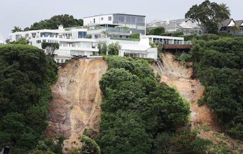
A further problem in Auckland is often the lack of adequate building “set-back” distances. This is the distance between a dwelling and a slope or cliff edge. In some countries and jurisdictions this is specified within regional plans and taken very seriously.
One way used to calculate these distances[8] is to project an imaginary 45 degree plane from the bottom of a slope. One third of the cliff height is then added to this. For example, a 30-metre high slope would have a set-back distance of 40 metres.
But local geology and climate is also important. With weak soils in a humid climate, a conservative rule of thumb could be a set-back distance of three times the height of the slope or cliff. So, a house on a 30-metre high North Shore cliff, with superb views across to Rangitoto Island, should be set-back around 100 metres from the cliff edge.
Yet there are many houses within just a few meters of cliff edges in parts of the North Shore and eastern Auckland. Swimming pools constructed on slopes can add to the loading and stress, making the slope more prone to failure during a significant rainfall event.
Set-back from the bottom of slopes is also important, because inundation (“runout”) from landslides on slopes above houses can occur, as witnessed in various parts of Auckland.
Three ways forward
Looking ahead, there are three broad approaches to mitigating rainfall-induced landslides in Auckland. First, it will be interesting to see how set-back distances are applied and whether changes to the Auckland Unitary Plan[9] are made in light of recent events.
The Earthquake Commission (EQC) covers land within eight metres[10] of homes and outbuildings. But many houses will now be much closer to the edge of properties. For houses still more than eight metres away from a failing slope, gradual slope creep may suggest future failure is only a matter of time.
Second, landowners should limit vegetation removal and make sure stormwater drains properly into reticulated systems, rather than informal soak-aways.
Read more: Climate change is already putting the heat on insurance companies – Auckland's floods could be a turning point[11]
Any surface cracking or bulging, cracked masonry, or difficult-to-open doors or windows should be checked by a chartered engineer. This can be useful in determining what is generally benign (but annoying) seasonal cracking due to soil shrinkage, and what is more serious.
Third, for scientists, engineers and local authorities, a more sophisticated region-wide approach to identifying unstable land is needed. The Interferometric Synthetic Aperture Radar (InSAR[12]) uses space-borne radar to measure ground surface movement at a scale of millimetres-per-year.
I led an EQC-funded team that successfully applied this technique to Gisborne from 2016 to 2021 using the European Space Agency’s Sentinel satellite constellation[13]. This provides measurements every 12 days, with the raw data being free. It has proved very useful to Gisborne District Council in their planning and decision making.
In Europe, the EU-sponsored European Ground Motion Service[14] displays almost real-time measurements of slope movements across the continent that anyone can access. Such a service would be useful across New Zealand – and the events in Auckland suggest this should be a priority.
References
- ^ broke all previous rainfall records (www.stuff.co.nz)
- ^ widespread damage (www.theguardian.com)
- ^ MORLEs (link.springer.com)
- ^ Kaikoura in 2016 (www.geonet.org.nz)
- ^ The Auckland floods are a sign of things to come – the city needs stormwater systems fit for climate change (theconversation.com)
- ^ some studies (www.nature.com)
- ^ Auckland floods: even stormwater reform won’t be enough – we need a ‘sponge city’ to avoid future disasters (theconversation.com)
- ^ calculate these distances (www.columbiaco.com)
- ^ Auckland Unitary Plan (www.aucklandcouncil.govt.nz)
- ^ covers land within eight metres (www.eqc.govt.nz)
- ^ Climate change is already putting the heat on insurance companies – Auckland's floods could be a turning point (theconversation.com)
- ^ InSAR (www.usgs.gov)
- ^ Sentinel satellite constellation (sentinels.copernicus.eu)
- ^ European Ground Motion Service (land.copernicus.eu)