

Millions of satellite images reveal how beaches around the Pacific vanish or replenish in El Niño and La Niña years
- Written by: Kilian Vos, Research Associate, UNSW Sydney
If you’ve been visiting the same beach for a few summers, you’ll have seen it change. While beaches look static, they’re actually one of the most dynamic regions on Earth. Winds, waves and tides stir and push sand around constantly. Storms can claw out huge volumes of sand and move it elsewhere.
On top of these changes is a hidden force – the El Niño Southern-Oscillation (ENSO) climate cycle. Our new research[1] explores how this cycle affects beaches around the Pacific Rim. Using cutting-edge satellite technology, we tracked changes over 40 years.
What did we find? The cycle matters a great deal. While the natural ENSO Pacific climate phenomenon affects weather patterns around the world, we haven’t fully understood how it affects beaches.
The main impact? Coastal storms intensified by the ENSO cycle. Storms can rapidly strip sand from beaches to create sandbars, dump it out at sea, or replenish another beach. These changes threaten to undermine beachfront properties and roads as well as beach habitats.
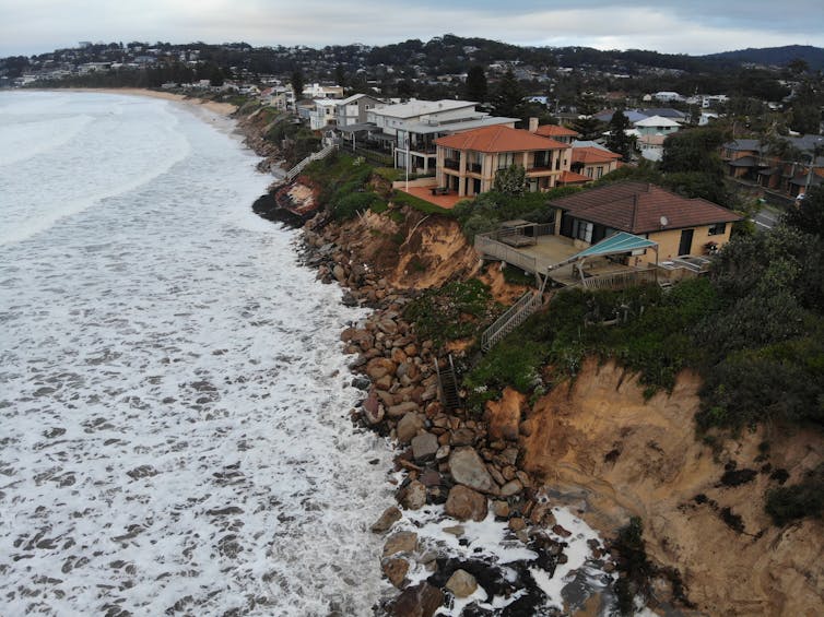
For Australia, if a La Niña is predicted to arrive in the next six months, coastal communities prone to erosion should prepare for storms stripping away sand. Our recent repeat La Niñas brought large waves and heavy erosion along the New South Wales and southern Queensland coast. During this period, houses almost fell[2] into the sea in the NSW Central Coast, while wild waves made a new passage[3] through Bribie Island.
During El Niño, Australia’s beaches recover, while beaches from California to Chile erode.
But as climate change ramps up, the effects of these ENSO cycles may become more intense[4].
What did we find?
We analysed millions of satellite images, looking for changes in beach width during El Niño and La Niña periods in southeast Australia, New Zealand, Chile, Peru, Mexico, California and Japan.
Lying in the satellite data was clear evidence of cyclical change. Along southeast Australia’s coastline, beaches tended to erode during prolonged La Niña periods, while regaining sand and recovering during El Niño years.
Read more: The wild weather of La Niña could wipe out vast stretches of Australia's beaches and sand dunes[5]
The reverse was true on the other side of the Pacific, around 13,000 kilometres away. From California down through Mexico to Chile and Peru, we saw beaches narrow during El Niño periods and widen out again during La Niña periods.
Why? Storms and sea levels. During El Niño events, large storms develop in the northern Pacific, sending energetic waves crashing onto the coastlines of California and Mexico — creating the perfect conditions for big wave surfing. During this period, the sea level is well above average too. Combined, bigger waves, storms and a higher baseline pillage sandy beaches. This is particularly pronounced in the eastern Pacific.
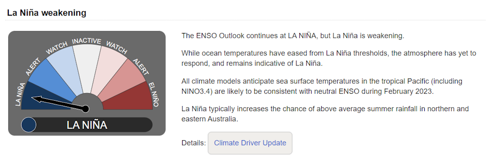
Knowing this, we can be better prepared. If you’re in Australia and the ENSO outlook[6] suggests a La Niña is coming, it might be time for councils to replenish erosion prone beaches.
Monitoring the many moods of a beach
Monitoring coastal change has long been carried out with on-ground techniques, such as GPS equipment, quadbikes and drones. These methods require human operators, which makes them expensive and limits the area and duration of observations. That’s why we have very limited on-ground observations of beach change along much of the world’s coastline.
That’s where satellites can help. Earth observation satellites have been capturing regular images of the world’s coastlines for four decades. Now we have the tools to interrogate the satellite images and track the evolution of sandy beaches.
Read more: Australia relies on data from Earth observation satellites, but our access is high risk[7]
We developed the open-source tool CoastSat[8] to automatically map the position of the shoreline on freely available satellite images, using cutting-edge image processing and machine learning techniques.
With tools like these, we can monitor coastal changes across thousands of beaches over the last 40 years. You can see how your local beach has changed on the interactive CoastSat website[9].
Read more: The wild weather of La Niña could wipe out vast stretches of Australia's beaches and sand dunes[10]
References
- ^ new research (www.nature.com)
- ^ almost fell (www.theguardian.com)
- ^ new passage (www.sunshinecoastnews.com.au)
- ^ more intense (www.nature.com)
- ^ The wild weather of La Niña could wipe out vast stretches of Australia's beaches and sand dunes (theconversation.com)
- ^ ENSO outlook (www.bom.gov.au)
- ^ Australia relies on data from Earth observation satellites, but our access is high risk (theconversation.com)
- ^ CoastSat (github.com)
- ^ CoastSat website (coastsat.wrl.unsw.edu.au)
- ^ The wild weather of La Niña could wipe out vast stretches of Australia's beaches and sand dunes (theconversation.com)